During the morning meeting we just had a recap of the week, nothing too exciting. Paige was late so I was sad and lost until she showed up. I met with Roger this morning to discuss what we'll be doing with his data. He's been studying the Jubilee Palimpsest. His way of analyzing data and his explanations about each procedure are completely different from Dave's. I've been struggling somewhat to bring out the under-text, mainly because my computer has been stuck on the 0% done loading bar for the past 10 minutes but also because this project is such a turn around from what we've been doing with Dave. After a few days I'm sure I'll pick it up and understand what's going on but until then I plan to mess with functions until I know each of their use. It's like the first day again, confusing and scary. Roger has been in and out all day checking on us so it's been helpful with him answering questions and then cutting us loose to try and fail. Hopefully tomorrow will be better along the lines of figuring things out. I'm mostly excited for the field trip Thursday so I've been thinking about that all day! I don't have a large amount of data to post about the palimpsest but I do have a few results that I'll add in later.

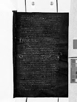
These are two results I have, the first one being an SAM result using the under-text as a region of interest. The second image is a PCA result done using bands 4,5,6. Neither of them show the under-text perfectly but they're a start

Comments
Post a Comment